One main goal of the INA
is to develop a new system of mapping our world -- one that
does not rely on geography, but on more meaningful parameters
like access to world markets or communications infrastructure.
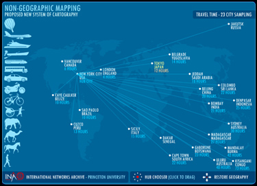
The following two maps were developed for the INA by Jonathan
Harris of Flaming
Toast Productions. The first map reconfigures 23 world
cities based on travel time between the cities instead of
distance. You can click on different cities, and the other
world cities will slide to reflect their travel time from
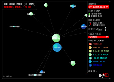
the chosen hub. The second map is a dynamically generated
system that is fed data files and automatically generates
non-geographic maps based on the data set. It is still a work
in progress, and many features have not yet been implemented.
To view the interactive maps, you will need the Macromedia
Flash 6 plugin. If you do not have it, click the button below
to download for free.

To view the maps, click the images below.
NON-GEOGRAPHIC MAPPING
PROPOSED NEW SYSTEM OF CARTOGRAPHY
DYNAMIC MAPPING
INTERACTIVE MAPPING EXPERIMENT
Click maps to enlarge them.
MORE
MAPS
MAPS ON THE INTERNET
International
Telephone Traffic in 1983 (Use Explorer)

Top
|