|
With all the talk of globalization it is easy to forget that
at the very core of the concept is a notion of geographical
location. Globalization involves connections between at
least two places and the first step in our understanding must
be an appreciation of what this means in a concrete sense of space. Mapping offers a possible solution to the dilemmas posed by the complexity of both network analysis and globalization. The tradition of data mapping has been popularized through Edward Tuftes beautiful books (e.g., The Visual Display of Quantitative Information, 1983). Interestingly, many accounts of earlier periods of globalization relied on such devices; there is a long tradition of using maps to tell a multilayered story encompassing time and space, exemplified by the work of Charles Joseph Minard: 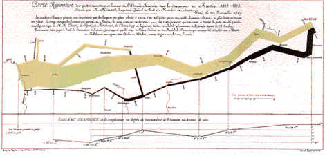 Maps are far from neutral representations of a reality. In fact, our understanding of globalization is shaped by the cartographic politics and conventions that define our image of the globe. But mapping has the advantage of requiring an explicit definition of geographical limits, foci, and units of analysis. With the development of computer graphics and GIS technology, the advantages of maps can be expanded through the addition of data layers that allow ever increasing levels of complexity. Despite the epistemological dangers inherent in mapping, no other technique so effectively and efficiently captures masses of data and relational positions. |
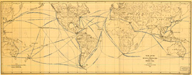 Trade routes and distances by existing lines and by the Panama Canal
U.S. Senate, Washington, DC, 1912 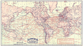 Steamship routes of the world
American Express Company, New York, circa 1900 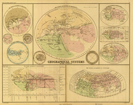 Geographical systems of the ancients
John Murray, London, 1874 |