|
Web
Exclusives:Features
By Erika Schielke '01
Captions, top
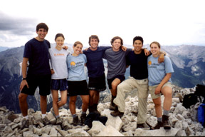
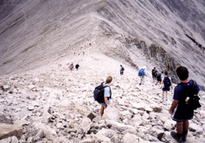
to bottom: The Outdoor Action Club's semi-annual climb of Mt. Princeton, a 14,197-foot peak in southern Colorado, was cancelled this year for lack of interest. But on July 21, just a week after OA's climb was to take place, I stood on the summit with four other members of the Class of '01, two members of the Class of '03, and one parent, carrying on the tradition in the absence of the official trip. Unlike several other members of our party, I hadn't signed up for the OA trip. However, when summer plans placed all eight of us near Mt. Princeton early in the summer, the climb was irresistible. Alana Benjamin '02, Anders Chen '01, Robin Clarke '01, and Mike Errecart '01 had all planned on participating in OA's climb. When it was cancelled, Benjamin and her father, Robert, residents of Los Alamos, New Mexico, decided to make their own attempt on July 21st. Jon Benner '03 and I were both working at the national lab in Los Alamos, and were eager to join them, as was Lisa Tan '01, another Los Alamos resident. Chen, who was spending the summer in Cheyenne, Wyoming, and Clarke and Errecart, who were in Boulder, Colorado, decided that they would meet us on the night of the 20th, and go up Mt. Princeton on the 21st, as well. Because of the large number of participants, the OA trip involves extensive planning, which begins long before everyone arrives in Colorado. Logistics for our group of eight were much simpler. Mr. Benjamin had planned meticulously, using A Climbing Guide to Colorado's Fourteeners to study the route, and reading J.I. Merritt's '66 detailed account of the 1997 climb. Errecart, Clarke, and Chen had planned independently for the climb, so all we had to do was coordinate our two groups. Meeting up with the Colorado and Wyoming contingent proved to be the most difficult part of our plan. It didn't seem that it could be very challenging to find the Mt. Princeton campground, which was clearly marked on the map ñ but in the dark, on unlabeled two-lane roads in rural Colorado, it took some guesswork. And then it was closed. After a fruitless search for our friends at the next campground, Benner, Tan, and I decided that we would just have to sleep at the trailhead. I was beginning to envy the Benjamins, who had opted to spend the night at a motel in Salida, about an hour from Mt. Princeton. The stars that still dotted the sky when we arose at 4:30 a.m. quickly faded as the eastern horizon lightened to gray. At 5:05 the Benjamins arrived, and by 5:15 we were starting up the trail. From an initial elevation of 8,900 feet, a jeep road winds gently up the lower slopes of Mt. Princeton, and, although lined with an aspen-sprinkled pine forest, affords frequent views out over the Arkansas River Valley to another range of mountains in the east. After we had been hiking for about 10 minutes, we stopped to admire the eastern horizon, where thin wisps of cloud were stained pink by the rising sun. The trail follows the jeep road for three miles, climbing slowly but steadily. Our party strung out in groups of two or three, chatting or walking in silence and breathing in the cool morning air and the fresh smell of the surrounding forest. Occasionally, jeeps or trucks carrying hikers rumbled up the road. With a four-wheel drive vehicle, it's possible to drive up most of the jeep road, cutting nearly six miles off the roundtrip distance. Most of the passengers waved and gave us slightly sympathetic looks. Mr. Benjamin had an altimeter with him. He had enlisted Benner and his daughter to calibrate it during the drive to Colorado, so we could measure our vertical climb. By the time we broke out the gorp at our first break, the sun had climbed high enough to bathe the Arkansas River Valley in golden early morning light, and when we turned around, the peak rising above us glowed a pale pink. We looked up at the rocky shoulder, trying to figure out whether it was the summit or some lower ridge ñ or another peak altogether. We didn't reach a consensus before we continued up the road. Our first solid landmark was a radio tower, a little over two miles from the trailhead. Most of the vehicles had parked here, and beyond the radio tower were several makeshift campsites, including one whose occupants were just preparing breakfast. The arm of the mountain blocked our view to the south, but to the north, the ground sloped down into a valley along the mountain's flank. There were expansive views over the Arkansas River Valley, where Mt. Princeton's slopes met the plains. We moved along at a steady pace, pausing occasionally for water. The path changed from dirt to talus, requiring more care with footing, but it was still fairly level. There were approximately 20 people ahead of us, small colorful figures dwarfed by the hulk of the mountain ñ apparently those who had driven past us on the jeep road or camped near the radio tower, since we hadn't been passed by any hikers. I was feeling surprisingly good, considering the altitude ñ about 10,500 feet. I had expected to be much shorter of breath, but I could hike along without gasping for air. I should have taken into account the fact that the trail, at this point, was still nearly level. The path continues gradually to an old mine, where it cuts sharply up the talus slope to the ridge. A descending hiker told Errecart, who was in the lead, that it was easier to cut up the slope before the mine, thus gaining the ridge earlier. I don't know about easier, at least not in terms of climbing the shoulder. Since we were on a talus slope, it was just a matter of choosing a point at which to climb up to the ridge. Previous hikers had apparently done this, as well, since we could see people at various points on the shoulder above us. The slope was steep, and there were patches of dirt among the boulders, allowing little purchase. By angling back and forth across the slope, we worked our way toward the top of the ridge. Suddenly, I was much shorter of breath, and I went slowly, trying to pick my way around the slipperiest parts. From the ridge top, we looked into a narrow canyon between Mt. Princeton and Mt. Antero, its neighbor to the south. We stopped and waited for all of our party to reach the ridge, looking out at a jumble of ragged peaks that had so far been shielded from view. The summit was now only about half a mile away. We could follow the ridgeline right to the top. Staying just below the ridge, on the north, we set off on the final leg. Up to this point, we had stayed more or less together, the leaders stopping every so often while the rest of our group caught up. On the final approach to the summit, we each moved at our own pace. I was having a harder time than I had expected. I was convinced that each breath was not giving me enough oxygen, and I felt as though I were moving at a snail's pace. I kept looking up at the summit, and at the members of our group ahead of me. The top didn't seem to get much closer, but the rest of my party kept looking farther away. Every few steps, I was tempted to stop to catch my breath. From the ridge, I had thought that I would push nonstop to the summit. I ended up taking a number of short breaks. There is a small knob just before the true summit, and as you go over that and up the final slope leading to the summit, you are out of sight of most people on the top. When I finally plodded up onto the summit, Errecart, Benner, Chen, Clarke, and Tan were there to greet me. I was out of breath, I could feel my face flushed with blood, and my legs were complaining. It was higher than I had ever climbed before, and it was wonderful. To the south and west of Mt. Princeton, a profusion of peaks reared up, a rock sea rolling into the distance. There was a slight haze, but not enough to interfere with the view ñ and under a warm sun, surrounded by friends on the summit, it couldn't have mattered less. The Benjamins joined us shortly, and we sat together, pulling out lunch food and extra clothing to ward off the light breeze. The first members of our group had reached the summit after around six hours of hiking, and within six and a half hours, we were together on top. We spent about half an hour there ñ more for those who were first on the summit ñ eating, lazing in the sun, and looking out at the surrounding peaks. Chen spent nearly 10 minutes carefully arranging smooth rocks, and then stretched out on this improvised bed and placed his hat over his face. Mr. Benjamin had carried a cell phone for emergencies, and Errecart asked to borrow it to call Rick Curtis, the Outdoor Action director. Benjamin, Benner, Chen, Clarke, Errecart, and I have all worked with Curtis as Outdoor Action leaders. After several tries, Errecart reached Curtis's voicemail. We left a group message, passing the phone around to let Curtis know where we were and what a beautiful climb it had been. Darker clouds had been moving in as we rested on the summit, so we enlisted Mr. Benjamin to take a picture of the rest of our group, and then headed down. There were at least 25 people below us, bright spots against the gray slope. Despite the gathering clouds, the majority were heading up. We pushed down steadily, frequently checking the sky, stopping only to allow the last hikers in our group to catch up. Pausing next to Mr. Benjamin, I asked him how he was doing. He looked out at the mountains surrounding us and shook his head. "I'm just trying to take it all in," he responded. Once we had descended the slippery talus slope, the going was quicker. As we continued down, Mr. Benjamin observed that his training hadn't quite prepared him for the climb, and outlined his plans for an ideal training tool. As he half-jokingly explained to Benner and Clarke, a stair climber would simulate the hiking, but it would have steps that unexpectedly rolled or sank, much like a tricky boulder in a talus field. A pressurized chamber would mimic high altitude, the sound of rolling rocks would warn of a rockslide, and a flashing warning would indicate an impending storm. The "hiker" who failed to increase his pace would be drenched with water. Luckily, we were not drenched. There were a few splatters of rain, but not enough to wet the trail. Once we reached the road, the remaining hike down was rather dusty, and seemed to drag on. Nevertheless, about three and a half hours after leaving the summit, we were all back at the parking lot, stripping off our boots and thankfully guzzling water stored in Mr. Benjamin's car. I don't think any of us really wanted to leave. Benner, Chen, Clarke, Errecart, and I planned on soaking in nearby hot springs and camping in the area, but Tan was heading back to Los Alamos with the Benjamins. We lingered in the parking lot, music drifting from the open doors of Errecart's car. It hadn't been the most pristine area I had ever hiked, or even the most difficult or the most beautiful. But the climb had been about more than distance and scenery, success or failure. It had been about sunshine and laughter, about the blending of class years and even generations in pursuit of a single goal. It had been, ultimately, about the people ñ the old friends and the new, united in our common desire to climb a mountain. You can reach Erika ateschielke@yahoo.com
|

 December
5, 2001:
December
5, 2001: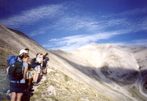 The
first OA-sponsored climb of Mt. Princeton took place in 1997, as
part of Princeton's 250th anniversary celebration. More than 200
participants attempted the hike, and 68 summitted. The 1999 climb
had 110 participants, but in 2001, too few people signed up for
the trip to take place.
The
first OA-sponsored climb of Mt. Princeton took place in 1997, as
part of Princeton's 250th anniversary celebration. More than 200
participants attempted the hike, and 68 summitted. The 1999 climb
had 110 participants, but in 2001, too few people signed up for
the trip to take place.
 We
also had trouble finding the trailhead, but finally, around 11:30
p.m., we pulled up alongside several other cars. Actually, we had
parked next to Errecart's car. He, Chen, and Clarke had also decided
to spend the night at the trailhead, and after a brief reunion,
we pitched our tent nearby and crawled inside for a few hours' sleep.
We
also had trouble finding the trailhead, but finally, around 11:30
p.m., we pulled up alongside several other cars. Actually, we had
parked next to Errecart's car. He, Chen, and Clarke had also decided
to spend the night at the trailhead, and after a brief reunion,
we pitched our tent nearby and crawled inside for a few hours' sleep.
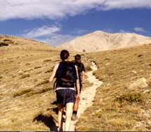
 After
another 1/2 of a mile, we finally left the jeep road and the trees
behind. Although the road continued along a shoulder of the mountain,
the trail branched to the right, climbing up and over a low ridge
before easing to a gentle grade through short grass and a few late
alpine flowers. Mt. Princeton's upper flanks and summit loomed before
us, and I could follow the thin line of the trail as it ran below
the ridge and then zigzagged up a talus slope to the top.
After
another 1/2 of a mile, we finally left the jeep road and the trees
behind. Although the road continued along a shoulder of the mountain,
the trail branched to the right, climbing up and over a low ridge
before easing to a gentle grade through short grass and a few late
alpine flowers. Mt. Princeton's upper flanks and summit loomed before
us, and I could follow the thin line of the trail as it ran below
the ridge and then zigzagged up a talus slope to the top.