
November 19, 2003: Features

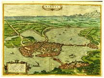 |
| Above, the city of Mantua, in a color engraving in an atlas entitled Civitates Orbis Terrarum, on display at the Art Museum.(Department of Rare Books and Special Collections, Princeton University Library/photograph by John Blazejewski) |
Italian
lessons
Exhibition
on Italian Renaissance cities offers ideas for today’s planners
By Catesby Leigh ’79
The charming island-city lies in the middle of a river that seemingly has bulged outward to accommodate it. Moles shelter two harbors. The cathedral, a monastery, a hospital, and public spaces are visible within the dense urban fabric. Two bridges, one of them doubling as a dam, link the island to one bank, while creating a lagoon; two causeways connect it to the other. Boats sail in the lagoon and the river. Little fortified suburbs lie on each bank, while a long wall running to a distant stream encloses farmland. Hills loom in the background of the verdant landscape.
The city might strike one as a utopian fantasy; in fact it is Mantua, depicted with astonishing skill in a color engraving included in an atlas entitled Civitates Orbis Terrarum, or Cities of the World, published in Cologne in 1575. It is one of the numerous treasures from the Firestone and Marquand Libraries on view at the Princeton University Art Museum through January 11, 2004. Containing just 21 items, “The Italian Renaissance City: Selections from Princeton University Collections” is a collaborative effort of the Art Museum and the Department of Art and Archaeology, with support from the Robert Janson-La Palme *76 Visiting Fellowship Fund.
Another book, On the Fortification of the City (1564), is opened to a view of an assault on the Sienese citadel of Montalcino by Spanish, German, and Florentine troops. We see the firing lines of the attackers’ artillery as it shatters the citadel and its obsolete curtain-walled fortifications. Also displayed are plans for fortified cities with multiple starlike salients that anticipate those of Louis XIV’s military engineer, Vauban. Here we encounter the fusion of perfect geometric regularity with practical considerations, such as the need to keep the possibly predatory garrison apart from the general population, or the need for a river running through the city for industrial purposes, along with the various uses of public squares – for the market, the municipal government, and so on.
Is all this of merely academic interest? No, says John Pinto, an architectural historian at Princeton and one of the exhibition’s organizers. “Studying the Renaissance achievement in city-building should help us think more critically about our own cities,” he says. Pinto points to the Mall in the nation’s capital, which is notoriously empty after 5:30 p.m. Studying the spatial organization of Italian Renaissance cities, and how it allowed private dwellings and businesses to sustain the public realm, he says, might help us make the Mall a vibrant precinct for a larger part of the day.
The Italians’ perfection of three-dimensional perspective drawing encouraged them to see urban space not in terms of privileged fragments set apart from the winding, undesigned lanes of the ordinary urban fabric, but as a homogeneous entity comprising streets and squares throughout the city.
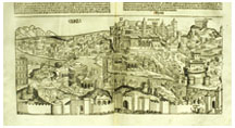 |
| Rome cityscape: Detail of Liber Chronicarum (1493), by Hartman Schedel; woodcut by Michael Wohlgemuth. (Department of Rare Books and Special Collections, Princeton University Library/photograph by John Blazejewski) |
Rome was the world’s foremost laboratory for the implementation of this concept. A 1575 vista of the city intended as a souvenir for pilgrims in that papal jubilee year – called Mirror of Roman Magnificence – is edited, and indeed distorted, to give priority to the city’s seven pilgrimage churches, with St. Peter’s reoriented so as to appear front and center. The Colosseum, the Castel Sant’Angelo, and the Tiber River are puny in scale. Rome was still a city of privileged fragments when this view was produced. To connect the pilgrimage churches, Pope Sixtus V, who was imbued with the Renaissance consciousness of urban space, placed obelisks and public fountains in such a way as to anticipate the cutting of new avenues and the improvement of old ones.
We get a foretaste of Sixtus’s ingenious plan of 1586 in a largely imaginary view of the southern flank of St. Peter’s, dating to the late 15th century. An Egyptian obelisk brought to Rome by the emperor Caligula is perched on a base so that its structural integrity can be ascertained (cover). Nicholas V, the first humanist pope, planned to move the obelisk to the east side of St. Peter’s as the first step in creating a grand new square. But it was Sixtus who got the obelisk moved a century later, and a century after that Bernini’s stupendous piazza was complete.
As a result of Sixtus’s plan, whose implementation continued into the 19th century, the scattered fragments of Eternal Rome were bound together in a spatial and architectural totality of unrivaled magnificence.
oday, the Renaissance concept of homogeneous space is highly relevant to urban design. Visitors to Minoru Yamasaki’s ill-fated World Trade Center towers and plaza encountered a vast urban fragment that might as well have been plopped down by giants from another planet. “The pre-9/11 WTC ran roughshod over the street system, and street life in the area was pretty dead,” Pinto observes. Similarly, Yamasaki’s Robertson Hall and Scudder Plaza created a self-contained precinct that, in spite of recent improvements, seem to have been arbitrarily plopped down on the Princeton campus.
The antithesis of Yamasaki’s fragmentary conception of urban space was realized by Robert Venturi ’47 *50 in the alignment of his Gordon Wu Hall (1984), which nicely defines a pedestrian corridor extending north from Goheen Walk, thus improving on the poor arrangement of Wilson College’s original buildings. This exercise in stitching together the campus is an example of what architectural historian Joseph Connors has called “incremental urbanism,” a technique consciously developed during the Italian Renaissance, whose urbanism Venturi has studied avidly since his student days.
In the most closely scrutinized urban design project now taking place in the U.S., the buildings Daniel Libeskind has designed for Ground Zero owe nothing to Renaissance Italy. But the site planning might be another matter. In her magisterial Death and Life of Great American Cities (1961), Jane Jacobs described continuous street networks as a key to thriving cities’ “close-grained diversity of uses.” Urban designers of the Renaissance would have agreed with her. And it appears the reconstruction at Ground Zero will restore two streets — one running north-south, the other east-west — that Yamasaki’s complex interrupted, while providing for a diversity of uses including offices, shops, cafés, cultural facilities, and a transit station, hopefully making for a 24/7 urban environment.
What modernist architecture now seems to lack is an enduring theoretical grounding. Renaissance Italy’s architecture and urbanism were grounded, quite simply, in the human body, whose harmonious proportions were the point of departure for all the arts based on drawing. Leonardo da Vinci’s famous image of the man of perfect proportions showed how the human figure could generate the circle and square, thus linking it to the divine geometries and harmonies suffusing the universe.
The New Urbanism pioneered by Andrés Duany ’71 and his wife and partner Elizabeth Plater-Zyberk ’72 owes a great deal to Italian Renaissance concepts of urban space and architectural decorum. But there’s a distance, too, Duany says. “To have cultural purchase” in the era of Michelangelo and Raphael, “architectural and urban design projects had to be presented in terms of the humanism of the Renaissance, with man as the measure of all things. Now they have to be presented in social or environmental terms to have cultural purchase.” Thus D.P.Z., as the partnership is known, emphasizes the social benefits of mixed-use neighborhoods whose residents have a range of incomes, and the environmental benefits of pedestrian-scale communities less dependent on the automobile than conventional postwar suburbs.
A student staring at that map of Mantua might wonder: Was the Renaissance
Italians’ humanism — their reliance on the human body as the
cosmic foundation of great design — just a matter of superstition?
“Fuor di questione,” many a modern pilgrim returning from Italy
would reply. “Out of the question.” ![]()
Catesby Leigh ’79 writes about architecture, urbanism, and fine art for numerous national publications.