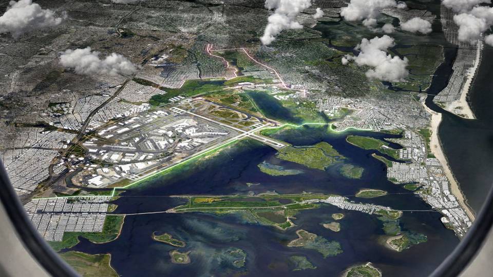
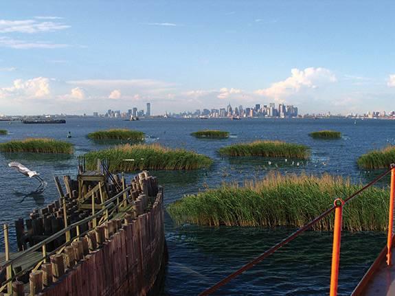
The wind, rain and waves of Hurricane Sandy in 2012 devastated homes along the New Jersey coast and beyond. Today, Princeton University climate scientists and architects are part of an interdisciplinary team exploring ways to co-exist with rising tides, including reengineering natural features, such as those imagined above, and designing "amphibious suburbs" that can tolerate periodic floods. The researchers aim for no less than a reinvention of flood hazard planning for the East Coast.
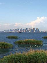
Image from "On the Water: Palisade Bay"
After the wind, rain and waves of Hurricane Sandy subsided, many of the modest homes in the Chelsea Heights section of Atlantic City, New Jersey, were filled to their windows with murky water. Residents returned to find roads inundated by the storm surge. Some maneuvered through the streets by boat.
This mode of transport could become more common in neighborhoods like Chelsea Heights as coastal planners rethink how to cope with the increasing risk of hurricane-induced flooding over the coming decades. Rather than seeking to defend buildings and infrastructure from storm surges, a team of architects and climate scientists is exploring a new vision, with an emphasis on living with rising waters. "Every house will be a waterfront house," said Princeton Associate Professor of Architecture Paul Lewis. "We're trying to find a way that canals can work their way through and connect each house, so that kayaks and other small boats are able to navigate through the water."
The researchers aim for no less than a reinvention of flood hazard planning for the East Coast. A new approach, led by Princeton Professor of Architecture Guy Nordenson, rejects the strict dividing line between land and water that coastal planners historically have imposed, favoring the development of "amphibious suburbs" and landscapes that can tolerate periodic floods. These resilient designs can be readily modified as technologies, conditions and climate predictions change.
To plan for future flood risks, Princeton climate scientists are using mathematical models of hurricanes to predict storm surge levels over the next century, taking into account the effects of sea level rise at different locations. Four design teams — from Princeton, Harvard University, the City College of New York and the University of Pennsylvania — are using these projections to guide resilience plans for specific sites along the coast: Atlantic City; Narragansett Bay in Rhode Island; New York City's Jamaica Bay; and Norfolk, Virginia.
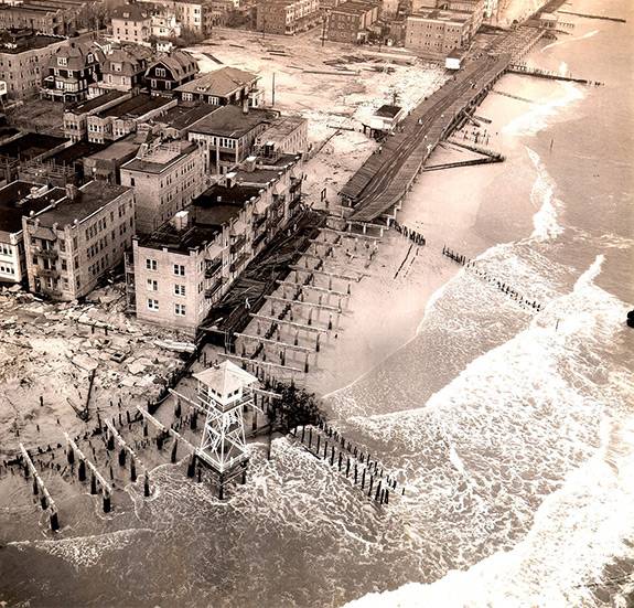
Storms have caused significant damage to Atlantic City's iconic boardwalk throughout its existence. Shown here is South Inlet during the Great Atlantic Hurricane of 1944. (Archive of the Beach Erosion Board stored at the Coastal and Hydraulics Laboratory, Engineer and Research Development Center, Vicksburg, Mississippi, USA)
The designs will serve as a guide for the U.S. Army Corps of Engineers' "North Atlantic Coast Comprehensive Study," a plan to reduce the risk of flood damage to coastal communities, which is due to Congress this month. "The Army Corps understands that they have to revisit what it means to make structures that are resilient," said Enrique Ramirez, a postdoctoral research associate in architecture at Princeton and the project's manager. He serves as a liaison between the design teams and Army Corps officials in regional districts.
The idea for the project grew out of Nordenson's work on a pre-Sandy project to develop creative proposals for adaptation to rising sea levels in New York Harbor. The project culminated in a book, "On the Water: Palisade Bay," and a 2010 exhibition, "Rising Currents," at the New York City Museum of Modern Art. The proposals included repairing and lengthening existing piers, as well as planting wetlands and building up small islands inside the harbor. "It was forward thinking because we showed that there are benefits to building things in the water," Nordenson said. Other Princeton contributors to "On the Water" were engineering professors James Smith and Ning Lin (then a graduate student) and climate scientist Michael Oppenheimer of the Woodrow Wilson School of Public and International Affairs.

Princeton researchers involved in the coastal resilience project are, from left: Paul Lewis, Ning Lin, Talea Mayo, Guy Nordenson, Michael Oppenheimer and James Smith. (Photo of Lewis courtesy of Paul Lewis, photo of Lin by Frank Wojciechowski, photo of Mayo courtesy of Talea Mayo, photo of Nordenson by Dominique Nabokov, photo of Oppenheimer courtesy of Michael Oppenheimer, photo of Smith by Frank Wojciechowski).
Hurricane Sandy in 2012 heightened the urgency of long-term coastal planning. While advising a New York State commission on future and use strategies, Nordenson began discussing a broader plan for the East Coast with Joseph Vietri of the U.S. Army Corps of Engineers and Nancy Kete of the Rockefeller Foundation. This discussion led to the Structures of Coastal Resilience project, which is funded by the Rockefeller Foundation and began in October 2013. The project is managed by Princeton's Andlinger Center for Energy and the Environment and will extend resilient design concepts to other coastal regions, as well as integrate hurricane storm surge predictions with projections of local sea level rise.
One of the project's goals is to encourage a reconsideration of the absolute flood zone boundaries on maps produced by the Federal Emergency Management Agency (FEMA), which determine building code requirements and insurance rates. Climate science shows that the geographical borders of flood risk should be based on the probabilities and outcomes of different storm events, not the placements of artificial levees that may be overtopped by high storm surges.
Indeed, many of the homes and businesses ravaged by Hurricane Sandy were not located in flood hazard zones on FEMA's maps. "Sandy really brought home the message that we have to do a lot better in the future," said Oppenheimer, the Albert G. Milbank Professor of Geosciences and International Affairs. "Because while we sit here thinking about it, the risk is only increasing."
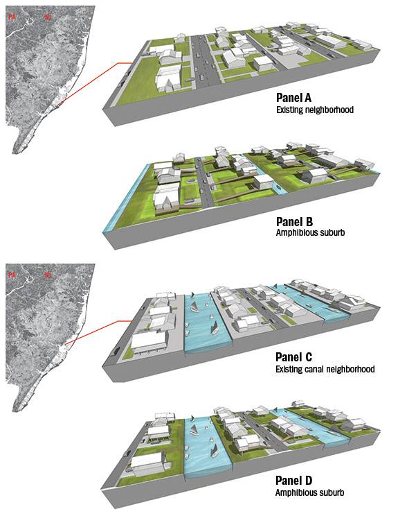
The low-lying barrier island that is home to Atlantic City is particularly vulnerable to storm surges, especially in parts of the city, such as residential Chelsea Heights, that were built on wetlands. Researchers are exploring ways to make existing neighborhoods (Panel A) more resilient in the face of occasional storm surges. By raising houses, using roads as low levees and letting abandoned lots return to wetland conditions, these neighborhoods can become “amphibious suburbs” (Panel B). A similar approach can be applied to existing canal neighborhoods (Panel C), making them more resilient and tolerant of flooding (Panel D). (Image courtesy of Paul Lewis, School of Architecture)
Smarter building codes are also needed, according to Lin, an assistant professor of civil and environmental engineering, who heads the effort to predict storm surge levels. Current building code books primarily address earthquake risks. "A tiny few chapters are for wind, and very few pages are for flooding," Lin said.
Large-scale, long-term projects such as levees and seawalls have been the standard approach to coastal protection. But the Coastal Resilience team puts forth a different view, one of coping with occasional flooding rather than fighting it. "We will never be able to prevent such hazards. We can only be prepared to reduce their impact," Lin said.
Resilient designs call for supporting, revitalizing and in some cases reengineering natural features such as wetlands and beach dunes. This so-called "soft infrastructure" can reduce the impact of waves, improve water quality and create new recreational spaces for coastal residents and visitors. Rather than the exclusive construction of barriers, the project's plans include "layered systems of natural and engineered structures that will respond in different ways to different hazards," Nordenson said. "It is a more nuanced and more resilient approach."
Flexible design is also an important component of the project. Ideally, the sizes and arrangements of structures will be adaptable as predictive models improve. Scientists continue to debate how climate change will affect the strength and frequency of storms. "But we are trying to take what we know right now and do the best job we can in accounting for the uncertainties in what we know, and use that to explore how we should be thinking about adaptation," said Smith, the William and Edna Macaleer Professor of Engineering and Applied Science and chair of the Department of Civil and Environmental Engineering at Princeton.
Meteorological measurements show that the extreme winds of a swirling hurricane transfer energy to the ocean surface. The winds and the storm's low air pressure cause a dome of water to rise, generating a surge of high water when the storm makes landfall. "When you think of the storm, you think of the wind and the rain. That's what seems scary," said Talea Mayo, a postdoctoral research associate who is working with Lin to model storm surges. But the coastal storm surge was the main cause of deaths and property damages from Hurricane Sandy.
To predict future storm surges, Lin and Mayo are using thousands of synthetic hurricanes modeled by Kerry Emanuel, an atmospheric scientist at the Massachusetts Institute of Technology. "Anytime you're studying hurricanes, especially so far north, your historical data are really limited because there just aren't enough events," Mayo said. "So instead of basing our risk analysis on historical data, we use synthetic data."
Emanuel's team uses existing models of global climate circulation patterns to generate 3,000 synthetic, physically possible storms for nine different climate change scenarios at each of the four study sites — a total of more than 100,000 storms. These hurricanes exist only in computer code, but their wind speeds, air pressure levels and patterns of movement are based on physical laws and information from recorded storms. Mayo and Lin plug these parameters into algorithms that work like sophisticated versions of high school physics problems: solve the equations for conservation of mass and momentum to estimate maximum water levels at each site. Variations in tide levels, coastline shapes and seafloor topographies add additional layers of complexity.
To make reasonable projections of future flood hazards, the models must also account for sea level rise. According to geoscientist Chris Little, an associate research scholar working with Oppenheimer, storm surges are a short-term version of sea level rise. "They both contribute to coastal flooding," Little said. "Climate change will be felt through the superposition of changes in long- and short-term variations in sea level."
And when it comes to sea level rise, local projections are crucial for planning efforts. A constellation of factors influence regional differences in sea levels, including the vertical movement of the Earth's surface, changes in ocean circulation and the melting of glacial ice. Little and Oppenheimer were among the authors of a study published in June 2014 in the journal Earth's Future, which used model-based and historical tide gauge data for sites around the globe to project local sea levels over the next two centuries.
"We live in a hotspot, where the local sea level rise has been higher in the past than the global mean, and we expect it to continue to be higher in the future," Oppenheimer said — as much as 40 percent higher than the worldwide average. One reason for this is that the land along the East Coast is slowly sinking (by a millimeter or two each year), a legacy of the ice sheet that covered much of North America until about 12,000 years ago. The ice sheet depressed Earth's crust over present-day Canada, causing the liquid mantle beneath to bulge southward. Now that the glaciers have melted, the mantle is being gradually redistributed, flowing out from under the East Coast of the United States.
Resilient designs call for planning and reengineering natural features such as salt marshes, submerged aquatic vegetation and wetlands, such as in this imagined coastline for Staten Island, south of Manhattan. (Image from "On the Water: Palisade Bay")
Sea levels respond slowly to changes in climate, including the current warming trend, caused in part by increased carbon dioxide levels from human activity. Because future carbon emissions depend on human decisions, predictions of sea level rise come with built-in uncertainty. This project attempts to meet this challenge head-on: "A major purpose of the project is to think about doing a more thorough job of assessing the uncertainty in these flood zones," Little said. "I think it's difficult but worthwhile."
Because of this uncertainty, climate scientists deal in probabilities. The Princeton team has projected flood levels for storms with return periods of 100, 500 and 2,500 years. A return period of 100 years is akin to a "100-year flood" — this means that in any given year there is a 1 percent chance of that flood level occurring. These forecasted flood risks are key to making smart building and design decisions in the face of climate change. "Every decision-maker is going to look and decide what risk is tolerable for their region in the context of how much it would cost to defend against that risk," Oppenheimer said.
The design teams are beginning to test their plans against the climate scientists' predictions. Simulated local water levels will reveal which structures may be inundated by future storms and at what probabilities. These analyses may prompt the designers to adjust the heights of buildings, roads or beach dunes in their blueprints. And as the science improves, this process will repeat itself. "Over time, others can start to add things that we haven't been able to include, like the relationship of the wind and the flood," Nordenson said.
True resilience necessitates a change in outlook. In Atlantic City, the focus area for Lewis and the Princeton group, a narrow channel of water separates the Chelsea Heights neighborhood from the city's famous boardwalk and high-rise casinos, where many residents work. "You have extensive areas of suburban neighborhoods that are built on wetlands," said Lewis. "Two binary positions are retreat, where you return these to wetlands, and fortification, which is the seawall approach. And both of them are problematic."
The team recognizes the social and economic importance of maintaining the neighborhood. But barricading it behind a seawall may be prohibitively expensive, not to mention unattractive. More important, metal or concrete seawalls can actually exacerbate flooding when areas behind them are inundated by heavy rain. Lewis and his team have a fundamentally different vision for places like Chelsea Heights: "We're looking at developing an amphibious suburb," he said. "We want water to come in. If there are berms [earthen seawalls] that are put in, they should be built with a series of valves."
The plans for Chelsea Heights include raised homes and roads interspersed with canals and revitalized wetlands. Lewis hopes these ideas will be useful to policymakers and to the Army Corps of Engineers, which may apply the Princeton team's concepts to Chelsea Heights and other similar communities along the New Jersey shore. By the end of this century, grassy suburban lawns may be transformed into salt marshes.
This article was originally published in the University's annual research magazine "Discovery: Research at Princeton."